Just like my May 2017 trip, the route for this one was based on information that I had been saving for years. It started with an article in Country Walking magazine in 2005 which described a 29.5 mile walk around Snowdon that included a new route through the Llanberis Pass. Unfortunately the piece was a bit short on some details, most notably a map for a start, so I sent a letter of enquiry (those being the pre-email days) to the National Park Authority, and received by return a colour leaflet that included a detailed map of the way up the Pass, which was called the Llwybr Peris Footpath.
Then in May this year a trip report was published on the v-g Backpacking in Britain website that included the National Trust Hafod y Llan Walk at the south side of Snowdon, of which I was not previously aware. Why not make up a circuit around the Snowdon massif, I thought, using the magazine article for guidance and including the Llwybr Peris and Hafod y Llan paths? Snowdon is somewhere I avoid because of its popularity, but I hadn’t been near it for 15 years and hopefully a route around it would be free of crowds while at the same time this would be a relatively low-level walk, with no serious heights to climb.
A web search turned up virtually nothing about either the 2005 circuit or the Llwybr Peris path, other than a 109-page pdf from 2008 that as far as I could tell was the same route. Nor did the Llwybr Peris path appear on the latest 1:25,000 map I had just bought. But during the search I chanced upon a route between Beddgelert and Rhyd Ddu, the Lon Gwrfai Walk , which was another bit I could follow! So with some sections pre-prepared, I worked out a way northwards from Rhy Ddu towards Llanberis via the pass of Maesgwm, with the completed plan looking more triangular than circular. A clockwise direction was decided on, and that only left where to start from.
The biggest problem with a starting point was the parking. Most of the car parks around my route are owned by the national park, with pay-and-display charges of £5 or £10 per day, and I wanted to leave my car for four days without returning to it. An option I considered was to leave my car further away and catch a bus in, to which end I added a pdf of the Snowdon Sherpa routes and timetable on my phone. In the end I decided to start from Beddgelert where I knew I had a chance of getting a space free of yellow lines in the village.
After studying weather forecasts for a couple of weeks I announced to my family that I would be going to North Wales on Monday 11 September as there was going to be heavy rain there on Sunday 10. This was hastily altered to Wednesday 13 when it became apparent that the remains of a tropical storm would be hitting the west of Britain on Tuesday 12 with winds of up to 75 m.p.h. So when I arrived at my chosen Beddgelert campsite, via its submerged access road, I heard tales from other campers of a sleepless night and collapsed tents. It was still gusty and there were sharp showers, but I had definitely missed the worst of it.
Day 1
After rising early (early for me, that is) the weather then decided to rain more on than off, and heavily at times too. This slowed me getting ready to the point that my hopes were dashed of getting a parking space in the village before they were all filled. A mistake was made by those running the campsite the previous day, when on learning of my plans they volunteered without me even asking that it would be OK to leave my car there. Another person now informed me there was a charge of £8 a day, so I parked in a layby on the main road outside their entrance. It wasn’t that bad a place to leave it, while it had the benefit of shortening the total length of my route by a mile. A short walk northwards along the road brought me to a public footpath, little-used as it became evident, that climbed westwards from beside a couple of cottages, steeply at first but then less so. When it reached a farmhouse and a track consisting of two

Moel Hebog
narrow strips of concrete for wheels, the day brightened up and I was able to remove my waterproof jacket, though I kept my overtrousers on all day because of the amount of overhanging wet vegetation. The huge flank of Moel Hebog filled the sky to the south-west.
Completely bypassing Beddgelert village, the track meandered down to the A4085 main road, which I followed for a few hundred yards northwards to the entrance of the forestry campsite (which was due to close soon for the construction of luxury holiday cabins and a limited number of ‘premium’ camping pitches). Plodding along the site’s tarmac roads, I was encouraged when I saw a sign pointing to the Lon Gwrfai route that I wanted. But that was the only sign, and once I had gone over a level-crossing for the recently reconstructed Welsh Highland Railway I hadn’t a clue. Fortunately my strategy of following a curving forest track from the far side, on the basis that it should reach the path I wanted, proved to be correct.
The route was like a wide stone-chip highway, on which it would have been very difficult to lose the way, not that it stopped a couple on bikes asking me where they were. I encountered other walkers, too, all genteel strollers apart from one heavily laden young man with a transatlantic accent who wanted to know how far was his destination of Nant Gwynant (about 8 miles). An information board beside the track helpfully named the peaks of the Snowdon group and the Moelwyns that were in the view to the east. While water was plentiful for my lunchtime stop, there was a shortage of something to sit on, until I spotted a green path in the trees leading to a wooden Environment Agency building that had steps up to it; these provided a modicum of comfort, and it was conveniently on the bank of the Afon Colwyn.
Some of the Lon Gwrfai walk is next to the Welsh Highland Railway, so I had hoped I would see one of its steam locomotives close-up, but as there was only one train each way in the morning and again in the afternoon it was a case of being in the right place at the right time, and I was unlucky. While I ate my lunch I heard one rattling along with its whistle blowing but out of sight, and later as I was passing Llyn-y-Gader I saw a distant one on the far side of the expanse of water. There the track runs parallel with the road and cars travelling in the same direction were matching their speed to that of the train.

Llyn Cwellyn
A fierce wind roared across the exposed causeway on which I walked around the north end of the lake, but I soon reached the terminus of the path at the road. Crossing this to Rhyd Ddu station and its car park, I felt a little bit out-of-place with the tourists as I wandered about with my water bottle looking in vain for a tap, of which there were none except in the public convenience. Not to worry, there would be streams in a while, and after making my way around a cottage or two I was away from civilisation again, except I was on another neatly-made stone-chip footpath. I had to pass a herd of cattle which, to my relief, ignored me, though they weren’t very large ones and I felt brave enough to whack any with a walking pole if it was necessary.
Beyond the twisting railway line which I had to cross again, the path became narrow and green, boggy in places too; this was much more the sort of thing I am used to in Snowdonia. It climbed gently into the hills, an

1st camp
undulating terrain of grass, rushes and rock, with grand retrospective views of the Moel Hebog group of mountains, plus the nearest end of the Nantlle Ridge and Mynydd Mawr. Along the way I started to look out for a tent pitch that was level, dry, sheltered and not far from water, a seemingly impossible combination here. The most difficult requirement to find was “level”, while “dry” was a close second, and it was only when I reached a wall by the waste tips of an extensive disused slate quarry that I saw what I wanted. When I had got my tent up and spread belongings along the ground by the wall, I had to hastily put them all under cover and crouch inside the tent while a shower passed.
Day 2
The day started with light cloud and little patches of blue in the sky, but thick grey clag hung low over the peaks. I was disappointed with how few miles I appeared to have walked yesterday, I expected to have got much further, and I hoped I might make up for it today. After I had crossed an adjacent ladder stile over the wall where I had camped, a trod way climbed very steeply up slate waste. Indicated by posts bearing plastic yellow arrows, the right of way went this way and that before descending an even steeper slope of slate. After this it went through grass and rushes around the base of the tips, level but ankle deep in mire and water. Then it climbed a rise, still going around the tips, before dropping steeply to a metal footbridge over a foaming mountain torrent. Anyone who fell into that wouldn’t get out again. The worst was not over, for on the far side the path rose so steeply that a bit of scrambling was necessary, which I didn’t find easy with my big pack and my poles. But beyond this the path simply rose northwards across a huge expanse of rushy moorland, on the east side of which Snowdon disappeared into cloud, with just its stump visible.

Maesgwm
After a very wet area I crossed the heavily-worn Snowdon Ranger Path, where I exchanged platitudes with a Canadian walker before I climbed a bit more to reach Bwlch Maesgwm at 467m (1,532ft) above sea level. From here I descended gently through the impressive v-shaped pass with green slopes rising steeply on either side. I had walked southwards up this pass many years ago, in 1989; it seemed more wild then because the path was now yet another stone-chip construction. On my way down today I was passed by a lady fell runner.
The path eventually became a wide, rocky track, still heading northwards and still an easy downhill gradient. Old ruined buildings lay at intervals below the right-hand side of the track, while two or three in seemingly good repair could be seen dotted about the wide and shallow valley beyond. During my descent I saw no fewer than four far-away steam trains on the Snowdon Mountain Railway which runs up the far side of the valley, and plain to see was its station Hebron that was my next objective.

Llanberis
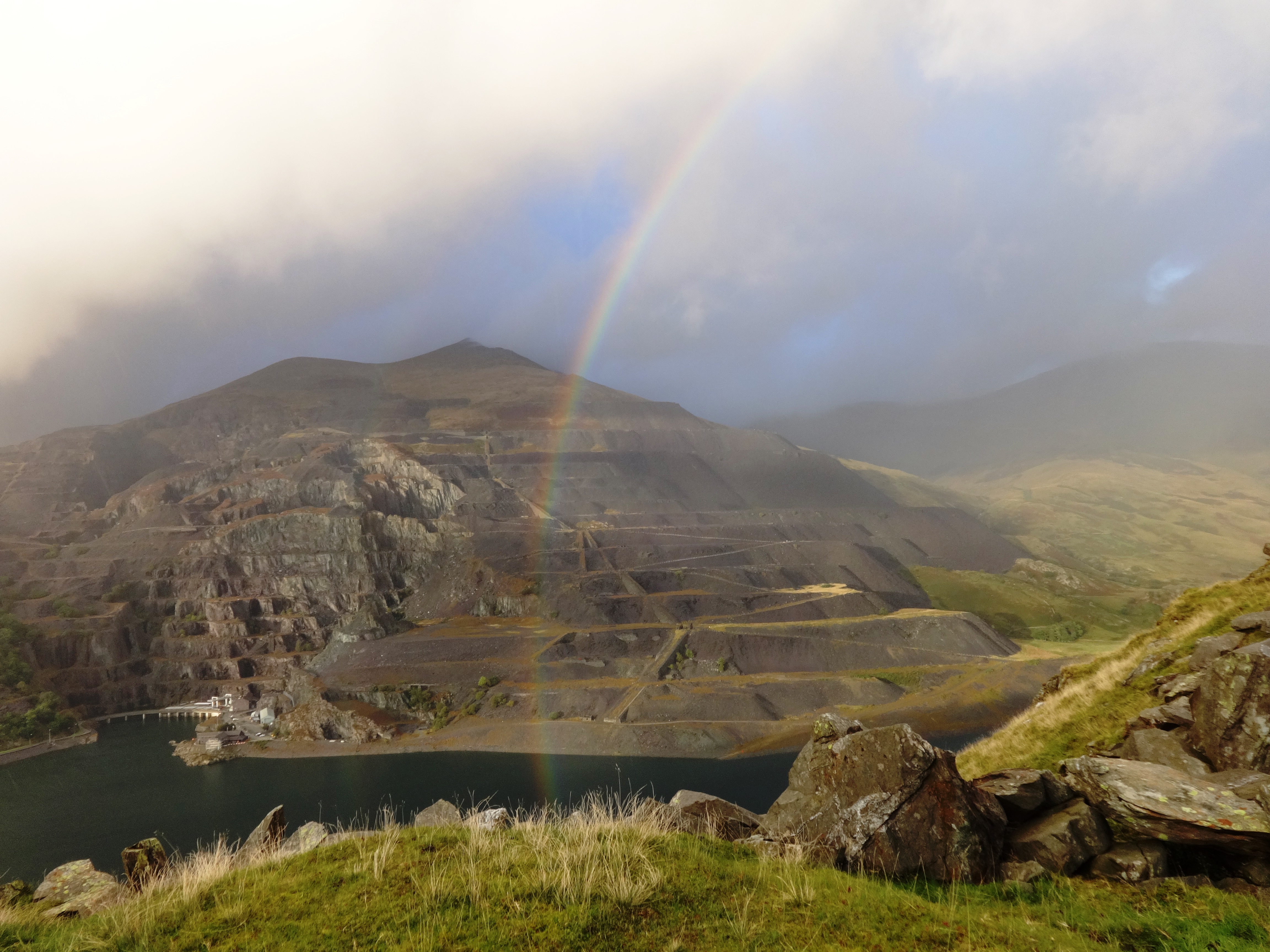
A series of paths, some grassy, some restored with flat stones, led me across the valley to the station which the sign said was at 326m (1,069ft). A train came down while I was here, but disappointingly it was hauled by a Hunsett diesel. Crossing the tracks I climbed a short path and, declining an offer of assistance from a woman in a passing trio of Polish walkers, I crossed a stile onto the Llanberis Path, a stony highway on which straggles of people were making their way back from Snowdon’s summit. Here I planned to use a public footpath shown on the Ordnance Survey map as heading roughly north-east then east over the hill to reach Llyn Peris; it is supposed to start opposite the station but I could not see it. After searching hard I found a very faint trod way heading steeply up the grass slopes, but when these eventually levelled off the path petered out. Passing a splendid view down onto the town of Llanberis and Llyn Padarn, I progressed over a final crest and downhill a bit to find myself on a flat-topped crag from which I could go no further. Precipitous slopes led down to trees below, beyond which lay goodness knows what.

Above Llyn Peris
While the view was not the most wonderful, with the opposite mountainside completely disfigured by the old terraces of Dinorwic slate quarry and beneath it the entrance of the pumped-storage power station on the edge of Llyn Peris, I realised that with flat grass, boulders and a crystal-clear spring of water from a crevice in the rocks behind, I wouldn’t find a better place to camp, so I put my tent up. This was the signal for light, showery rain to commence, so I was more-or-less confined to my shelter for the evening, during which some strange subterranean noises emanated from the power station; to my relief these did not continue for too long, as I was worried that they might have disturbed my sleep.
Day 3
Elidir Fawr
The morning was dry but lightly clouded. My task after setting off was to find a way off the escarpment I was on. Climbing back from it to the level area beyond the crest behind me, I looked down a rough grass and bracken hillside on the west; this looked like the best bet. It was incredibly steep, forcing me to sit down and lower my feet in places, and completely pathless except when I was able to follow where sheep had forced ways through the bracken. After approaching the stone-walled boundary of Coed Victoria I changed direction first roughly northwards and then to the east, just like the path shown on the map, although it was beyond doubt that this did not exist on the ground. At a lower altitude still, I reached a wall beyond which was rough sheep pasture; crossing the wall was made easy by a fallen tree that had knocked some of it down. Then I came to a wire fence around the grounds of a bungalow with a number of cars, most of which looked like non-runners. With no windows facing me I followed the fence to a point where I could get my leg over it. A high privet hedge shielded me from being seen from a large window on the front of the property as I trod daintily across a corner of a lawn to reach a tarmac drive that led down to the A4086 main road, where I breathed a huge sigh of relief. It had taken nearly an hour and a half since I had left my overnight site.
Grateful that there was a wide pavement, I set off southeastwards on a long tramp to the end of Llyn Peris. This was not that pleasurable, but it had to be done. Along the way I couldn’t help but notice a continual stream of keen-looking cyclists heading towards me, far more, I thought, than one might expect to see on a Saturday morning. Calling out to a pair who were passing slightly less energetically, I asked if there was a race on. “There is,” came the reply, “but we’re not in it, we joined it by accident!”
 At last I reached where a wide track veered off to the right; this was the start of the route shown on my Llwybr Peris leaflet. A sign by a flat pasture warned that it was not to be used for camping as the area was used by rescue helicopters. After half a mile I passed a footbridge over the river, beyond which the path diminished to virtually nothing between dense rushes. This didn’t look right to me but I persevered until I reached the side of a copse where a new wire fence was under construction. Past this the going became more overgrown with shrubs and other vegetation, and then there was a stone wall that stretched away up the mountainside without a break. My leaflet showed a ladder stile crossing it at a specific grid reference, but I could not see one. It appeared that the project of 12 years ago had been abandoned, which would explain why there was no information about it online, while the barely-trod way I had just followed was only made by the fencers getting to their site.
It was time for a hastily thought-up Plan B. Very disappointed that the route did not exist and simultaneously cross at the time I had wasted, particularly on top of my exertions earlier this morning, I returned all the way back to the footbridge. Crossing this, I followed paths to reach the main road where it passes through the tiny community of Nant Peris. The first thing that caught my eye here was a bus stop on the other side of the road. An idea quickly took shape: I was way behind schedule, the continuation of the road up the Llanberis Pass lacked a pavement, and it was all uphill, so why not catch a Snowdon Sherpa to the top? The timetable confirmed that one was due in about 40 minutes, which would just give me time for a quick half of ale in the Vaynol Arms pub that was conveniently situated opposite!
After my impromptu refreshment I passed the time at the bus stop with a fellow Londoner who was staying on the nearby campsite, outside which was a checkpoint for the cyclists; this showed they were competing in a 24-hour triathlon. The little bus was right on time, and only contained three other passengers, one of whom was a small boy who was sitting right at the front and informed me I could put my rucksack in the place behind him that was designed for luggage.
“Is he going to be a bus driver when he grows up?” I asked the operative, presuming they were related. “I hope not!” came the reply.
So for £1.50 I enjoyed an easy journey for the remaining three miles or so to the top of the pass, though I didn’t see much of the magnificent scenery. We passed a line of young people walking at the side of the narrow road, which left me glad I hadn’t done that. The bus pulled into Pen-y-Pass car park where a crowd were waiting to go down to Llanberis, while just as many could be seen walking in both directions on the Miners Track. Feeling immensely pleased that I was back on schedule again, I headed south-eastwards towards the valley of Nant Gwynant. The path was yet another reconstructed one, this time made of flat rocks; later I was to descend man-made stone staircases.
Even here I saw more people than I am accustomed to on my walks, I think they were trekking to and from the isolated Pen-Y-Gwryd Hotel, famous for its Everest memorabilia, but the first one I encountered amazed me; a young man kitted out in proper gear, he passed me on the path with no nod, no greeting, in fact not even a glance towards me. Puzzled, I looked at my legs and held out each arm to make sure I hadn’t become invisible. It was considerably colder up here, and when I stopped for a late lunch at a huge boulder that had a seat-like ledge along its downwind side, I added lots of extra clothing. When I failed miserably to prop my camera on the rock to take a self-portrait, a passing Portuguese couple kindly took a picture for me.
After descending to Cwm Dyli hydroelectric power station the path crossed the Afon Glaslyn on a narrow stone slab footbridge. Here there was an iron gate of a sort common in Snowdonia, whose farmers string up a weight, usually a stone, that pulls the gate closed, but in this instance an old starter motor had been utilised for the purpose. From here onwards the path and the surrounding land were extremely wet, frequently under water in fact, with no alternative but to walk through it.
Just before the northern end of Llyn Gwynant there is a campsite, this had been completely taken over by the organisers and competitors of the triathlon that was taking place, leaving me glad that I hadn’t planned on using the site. The path southwards was even worse than the way I had walked to get here, it was more like a puddle-filled ditch while alongside it were uneven boulders in churned-up mud. It was obvious that the runners in the triathlon had passed this way earlier.

Wild goats
The path began to climb through trees till it was following steep contours high above the west shore of Llyn Gwynant. Not helped by the wet muddiness left by the runners, some sections needed the help of hands grasping trunks and rocks, but eventually I was at the highest point, where my efforts were rewarded by the wonderful sight of four young black-and-white wild goats, who kept wary eyes on me but didn’t flee. Descending from here was possibly more steep that the way up, with much more hanging onto trees being necessary. I had walked the length of the lake in 2002 but I had no recollection of it being like this. Only later did I discover that I had blindly followed the trail left by the runners, and I had missed the main path a long way back, which would have saved all of this.
Worse was still to come, for the narrow path headed down to the lake’s shore, along which a rock field lay between the slopes and the water’s edge. Here I progressed at a snail’s pace as I searched for level surfaces and cautiously stepped from one boulder to another, balancing myself with my poles as I went, before pausing to work out my next move. Signs of trampling here and there showed the runners had been this way, which gave me encouragement; if they could do it so could I, and though they would undoubtably be younger and fitter than me, and not weighted down with backpacks, I imagined they would be more likely to break an ankle than me.
It was a huge relief when I reached the end of the rocks and was able to continue at a fast pace through relatively flat woodland beside the lake. Knowing that I would soon reach “civilisation” in the form of Hafod-y-Llan farm, I started keeping an eye out for somewhere to pitch my tent for the night but there was nowhere suitable; possible sites were too wet, and further on they were too much in the open. There were nice spots close to an outdoor pursuits centre that was plainly not in use at the moment, but I couldn’t take the risk that a group might arrive before I left in the morning.
Less than a mile further along a hard-surfaced track was the small and basic National Trust camp site, and that is where I decided I would stay. As it was a Saturday night I shared it with eleven other tents, and while I did wonder about the four beer-drinking lads in the nearest one, everyone turned in early and it was a quiet night.
Day 4
In my situation I really did not feel there was much advantage in paying to camp like this. My tent was pitched next to split tree trunks that were good for sitting on and spreading gear on, but that was no big deal. The sole tap had a sign warning to boil the water, so I had to use my Steripen just the same as I would with a stream or lake. The w.c. was more civilised than watering trees or rushes, and had I needed it for anything more it would have saved me from scraping a hole in the ground. The only real benefit was warm water from the free but not very efficient shower, that saved me from heating water with my stove for washing. I didn’t actually have a shower because neither my tiny bar of hotel soap or my little Pertex towel would have been sufficient, and I expected to be showering at a bigger camp site this evening using better items that were in my car.

Lliwedd
The next stage that I had planned was the National Trust’s Hafod y Llan Walk which for me was more of a winding detour than a direct route. I joined it a little further down the lane from the camp site, where it initially follows the beginning of the Watkin Path that ascends Snowdon. Having climbed a rocks-and-gravel highway through a wood, a splendid view opened up of Cwm Llan waterfall and the south side of 898m (2,946ft) Lliwedd. Small groups of walkers could be seen on the path ahead, and I was overtaken by a not-so-young German couple. The man was in a short-sleeved summer shirt while their miniscule rucksacks could not possibly have contained much in the way of warm clothing or waterproofs, so I hoped the weather was going to remain kind for them, but they had done it before, I was assured.
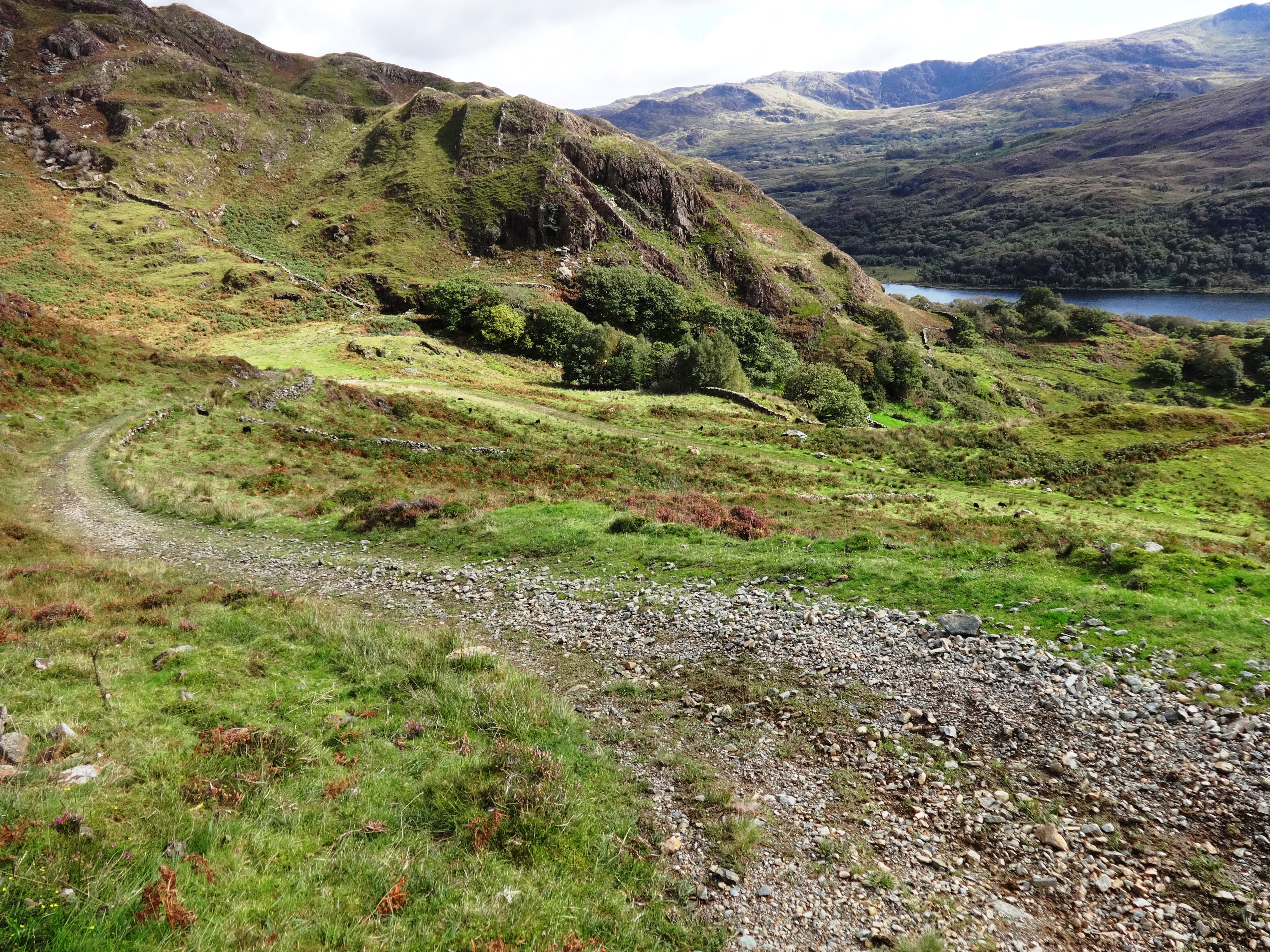
After little more than half a mile I turned left, south-westwards, onto a minor path where a metal sign on a short concrete post pointed to Craflwyn. This path climbed gently but continuously for about a mile up Bwlch Terfyn to about 330m altitude (1,080ft) where I then looked down onto a shallow valley descending to the west, with the familiar peak of Moel Hebog on the distant skyline. After exploring the remains of a disused copper mine (see http://www.penmorfa.com/Lliwedd/index.html for information), I continued on my way downhill, passing a number of black Welsh highland cattle that turned out to be the most docile beasts you could wish to encounter; if only they were all like that!
The path became a stony track that continued downhill and eventually entered woodland where a fallen trunk next to a fine waterfall and a stone slab footbridge was the ideal sitting place for lunch. Shortly after this there was a fork in the path where I turned right, following pointers on a wooden post. I soon began to climb, while the path was turning back towards the way I had come, but I persevered, assuming it was going to loop back around again. It did not. There was a fine viewpoint looking across the Moelwyns towards 689m (2,260ft) Cnicht, before I turned back, annoyed at the wasted time and effort. On reaching the fork in the path again, there were signs on this side of the post that were lacking on its other side, showing too late that I should have taken the other way.
View to E
More delightful woodland with streams and little waterfalls was passed, until I reached Craflwyn Hall, a Victorian former hunting lodge by the main road, a short distance along which my car was waiting for me in its layby. I drove immediately to a well-appointed campsite in Shropshire where I relaxed with my big tent for three days before returning home. Reflecting on my walk, I was a little disappointed with it overall, in spite of the majestic scenery. This was not least because it was often not far from main roads, “civilisation” and people – I think I encountered more people than I have in the last ten years of such walks – but my main reason is that most of the way was on stony tracks or heavily restored paths. These were quite the opposite of the faint trod ways in grass that I am more accustomed to and which, I have decided, I definitely prefer.
Click Here to return to The Walks page.
